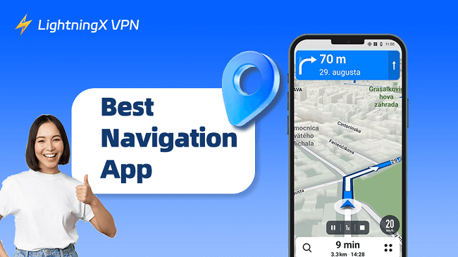
To be honest, getting lost is no fun. Whether you’re commuting, traveling, or working, having a reliable GPS app can make your life much more convenient. Over the years, I’ve tried dozens of navigation apps. Some are excellent, while others…
In this guide, I’ll recommend the 15 best free GPS navigation apps and provide tips on choosing the one that suits your needs.
Price: Free | Available on: iPhone, Android, Web | Offline maps: Yes | Real-time traffic: Yes
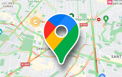
Google Maps is the most popular free GPS navigation app, trusted by millions of iPhone and Android users. Whether you’re driving, biking, walking, or taking public transportation, Google Maps provides precise directions and real-time traffic updates, helping you get where you want to go faster and easier.
Simply open the Google Maps app, enter your destination, select your mode of transportation, and tap “Start” to begin navigation. You’ll receive turn-by-turn voice navigation and intelligent route adjustments based on current traffic conditions. While the app is very reliable, it does have some limitations, such as a maximum of 10 stops per trip and occasional out-of-date Street View imagery.
Key Features of Google Maps
- Real-time ETA adjustments based on live traffic conditions.
- Turn-by-turn navigation for driving, walking, cycling, and public transit.
- High-quality Street View and immersive 3D mapping.
- Offline maps for navigation without internet access.
- 360° views and detailed layouts of selected buildings.
- Available on iOS, Android, and the web.
Price: Free | Available on: iPhone, iPad, Apple Watch, CarPlay | Offline maps: Limited | Real-time traffic: Yes
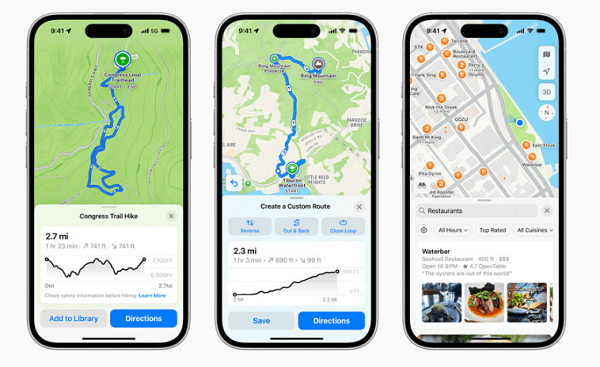
Apple Maps is the default free GPS navigation app for iPhone and iPad users. Its clean design and privacy-focused design make it a great alternative to Google Maps.
You just open Apple Maps, enter your destination, select your travel mode, and tap “Go.” The app provides voice navigation, real-time traffic updates, and intelligent rerouting.
However, it is only available for iOS users, has limited offline functionality, and its database of points of interest isn’t as detailed as Google Maps.
Key Features of Apple Maps
- The interface is simple and intuitive, with minimal ads.
- Real-time traffic updates and intelligent routing.
- Look Around provides 360° street-level imagery.
- The flyover tool allows for 3D virtual tours of cities and landmarks.
- Integrates with Siri, Apple Watch, and CarPlay.
- Provides information on electric vehicle charging stations.
3. HERE WeGo: Best Free GPS App for Offline Use
Price: Free | Available on: iPhone, Android, Web | Offline maps: Yes (100+ countries) | Real-time traffic: Yes
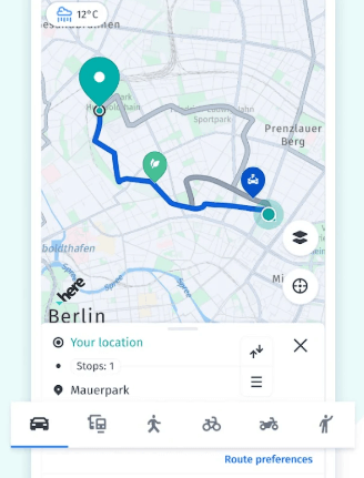
HERE WeGo is a free GPS app designed for city navigation. You can download maps for over 100 countries worldwide, making it easy to navigate even without internet.
Open HERE WeGo, enter your destination, and select your preferred mode of transportation. This app will show you the best route and provide real-time traffic updates. My favorite thing about it is the extra information it provides before setting off, such as parking availability and traffic conditions. This saves me from driving aimlessly around looking for parking.
It’s also popular with delivery drivers and couriers thanks to its reliable offline maps. The only downside is the occasional ad, and some offline maps aren’t as updated as the online version.
Key Features of HERE WeGo
- Offline maps for over 100 countries.
- Real-time traffic information and parking availability.
- Navigation for driving, walking, cycling, and public transport.
- Save favorite locations in collections for quick access.
Price: Free | Available on: iPhone, Android | Offline maps: No | Real-time traffic: Yes
Waze is a GPS app known for community-driven traffic updates. It relies on real-time reports from millions of drivers to provide instant updates on accidents, traffic jams, road closures, and speed traps.
Many drivers say they appreciate its lane guidance and forward hazard alerts, which help make their journeys smoother and safer.
However, Waze doesn’t support offline maps, and continuous GPS use can drain your phone’s battery faster.
Key Features of Waze
- Real-time, crowdsourced traffic updates from other drivers.
- Voice navigation with live rerouting.
- Lane guidance to help with highway exits and complex turns.
- Alerts for accidents, hazards, and speed traps.
- Integration with music and podcast apps for in-car use.
- Available on iPhone and Android.
5. AMap Global: Best Free GPS App for China
Price: Free | Available on: iPhone, Android | Offline maps: Yes | Real-time traffic: Yes
Amap Global Edition is one of the most popular navigation apps in China. Since Google Maps lacks comprehensive coverage in Chinese cities, Amap fills this gap with its detailed and highly accurate local coverage. It offers real-time traffic alerts, lane-level navigation, and intelligent route planning.
Open AMap Global, enter your destination, and choose your preferred mode of transportation. This app provides turn-by-turn voice navigation, dynamic route adjustments, and offline map downloads, ensuring you can reach your destination smoothly even without internet.
Key Features of Amap Global
- High-precision maps covering Asia.
- Real-time traffic conditions and intelligent route planning.
- Supports driving, cycling, and walking navigation.
- Lane planning and voice guidance.
- Offline maps for international travelers.
Price: Free and Paid | Available on: iPhone, Android | Offline maps: Yes | Real-time traffic: Yes
Sygic is one of the most feature-rich GPS navigation apps, trusted by millions of drivers worldwide. It features offline maps for every country in the world, powered by TomTom, so you can rely on it even without an internet connection.
For electric vehicle owners, Sygic helps you find nearby charging stations, check availability, and pay directly within the app. While the free version is powerful, most premium features require a subscription.
Key Features of Sygic GPS Navigation
- Offline maps for every country in the world.
- Turn-by-turn voice-guided navigation with pedestrian mode.
- Lane assistance, speed limit alerts, and safety warnings.
- Real-time traffic updates and electric vehicle charging station information.
- Additional features include a heads-up display, a dashcam, speed camera alerts, and celebrity voiceovers.
Price: Free (Premium upgrades available) | Available on: Android | Offline maps: Yes | Real-time traffic: No
BackCountry Navigator is designed for outdoor enthusiasts who love hiking, mountain biking, and off-roading. Unlike city-focused GPS apps, it features detailed topographic maps and robust offline navigation, allowing you to find your way even in the wilderness without cell service.
My favorite aspect is its customizability. You can record tracks, add waypoints with custom symbology, and even load pre-set offline maps in the Mobac style. Even when I’m not actively recording a route, I can view location statistics at a glance, which comes in handy when I need to check elevation or distance traveled.
While it may not look as polished as paid apps like Gaia GPS, the free version is sufficient for most needs.
Key Features of Backcountry Navigator
- Fully functional offline maps for remote navigation.
- Track recording with detailed stats and waypoints.
- Customizable waypoint symbols and route planning options.
Price: Free | Available on: Android, iOS, Web | Offline maps: Limited | Real-time traffic: Yes
Citymapper was designed with a clear purpose: to make cities more convenient. It’s one of the best free navigation apps for commuters. Citymapper not only provides bus and train route information, but also lets you plan walking, biking, scootering, and even a combination of various modes.
My favorite aspect of Citymapper is its detailed real-time traffic updates. Not only can you get route information, but you can also see the arrival time, current status, and expected wait time for your bus or train. It saves me time on my daily commute.
The only downside is that Citymapper is still limited to major cities, so if you live in a smaller town, it might not be available for the time being.
Key Features of Citymapper
- Multi-transportation options: buses, trains, walking, cycling, and more.
- Real-time transit status with live arrival times.
- Cost, time, and energy comparisons for each travel option.
When using GPS navigation apps, your location and personal data could be exposed. That’s where LightningX VPN comes in handy. It encrypts your connection, keeps your online activities private, and even prevents ISP throttling.
LightningX VPN also offers over 2000 high-speed servers worldwide, ensuring smooth navigation no matter where you are, without affecting your GPS location.
In addition to the above free navigation apps, here are more choices you can try:
1. Moovit
Moovit is designed for commuters who rely on buses, trains, or subways. It covers 3400+ cities worldwide and provides real-time arrival times, route suggestions, and service alerts.
My favorite feature is the real-time arrival notifications, especially when taking public transportation in unfamiliar cities, which makes it virtually impossible to miss your stop.
While Moovit is free, if you want to remove ads or unlock advanced features, you can subscribe to Moovit+ from $0.99/month to $ 19.99/year.
2. CoPilot GPS
CoPilot GPS offers offline navigation designed for drivers who frequently drive long distances or travel through areas with poor network coverage. You can download maps in advance and use them anywhere.
The app’s basic features are free, but premium options like real-time traffic and advanced routing cost between $9.99/month and $119.99/year.
3. Hikingbook
Hikingbook is designed for outdoor enthusiasts who love hiking and mountain adventures. It offers features like GPS tracking, route logging, elevation profiles, and offline maps.
My favorite feature is the elevation log, which clearly displays my climbed heights, providing both motivation and practicality.
The paid version of Hikingbook offers advanced weather integration, offline map layers, and more. It costs $6.99 per month or $46.99 per year.
4. Karta GPS
Karta GPS is a navigation app focused on offline maps, perfect for travelers with spotty internet connections.
The app is free to download and use, but it does contain ads. If you want to remove ads and unlock more features, you can upgrade through in-app purchases, starting at just $4.99 per month.
5. Badger Maps
Badger Maps is perfect for sales professionals who need to plan multiple stops throughout the day. It optimizes routes, helps schedule customer visits, and even integrates with CRM systems like Salesforce.
Badger Maps offers a free trial. However, to unlock full features like route optimization, check-ins, and CRM synchronization, you’ll need a subscription, starting at $49 per user per month.
6. Maps.Me
Maps.Me offers global coverage and allows you to download maps for free by country or region.
Its offline maps are very useful. Even in remote areas without service, you can still search for places, find restaurants, or view nearby attractions.
Maps.Me is free to use but does have ads. If you want additional features, you can upgrade through in-app purchases, starting at $1.49 per month or $14.99 per year.
7. Sygic GPS Truck & Caravan
Sygic GPS Truck & Caravan is designed for drivers of larger vehicles like trucks, RVs, and travel trailers. It takes into account your vehicle’s size, weight, and load type to create safe and optimized routes.
It helps you avoid low bridges, narrow roads, or weight restrictions, making it easier to navigate large vehicles in unfamiliar areas.
The app is free to download, but advanced features like real-time traffic, speed limits, and truck-specific routing require a paid subscription, starting at $139 per year for the Pro plan.
Choosing the right GPS app can make your journey smoother. I’ve tested quite a few, and here are my experiences:
1. Offline Map Support
If you’ve ever gotten lost in a place without a signal, you know how important offline maps are. The best navigation apps offer offline map downloading, like HERE WeGo or Maps.Me, so you won’t be stranded even without an internet connection.
2. Real-Time Traffic Updates
I hate being stuck in traffic, and apps that adjust routes based on real-time traffic conditions are a lifesaver. Google Maps and Waze do a great job of this, alerting me to accidents, congestion, and even speed traps. If a navigation app doesn’t do this, I usually avoid it.
3. Coverage and Accuracy
Some GPS apps work perfectly in big cities, but struggle in rural areas. If I’m traveling internationally, I choose an app like AutoNavi, which is much more reliable in China than Google Maps.
4. Device Compatibility
It’s annoying if a GPS app doesn’t work on every device. If you need to switch between an iPhone, an Android, or even your car’s display, make sure the app supports those devices.
5. Privacy and Data Usage
Privacy is very important to me, and probably to you, too. Apple Maps wins in this regard because it doesn’t track my movements, while Google Maps offers better recommendations but may collect too much data.
Final Thought
For everyday navigation needs, I stick with Google Maps or Apple Maps because they’re reliable, easy to use, and get me to my destination easily. If you rely on public transportation, Moovit and Citymapper offer better experiences. For hiking or off-roading, nothing beats BackCountry Navigator or Hikingbook.
Once you find the GPS app that works best for you, every trip will be easier and safer.